
If you do a lot of running, you’ll often find that you’d like to keep track of how much distance you’ve accumulated. This is especially important if you’re training for some event, or even if you’re just a casual runner looking to build up your endurance and stay in shape. However, short of running around a track endlessly, it can be hard to gauge how far you’ve gone on your running route.
Short of having a fancy device such as the Nike iPod Kit (which requires calibration), or an even more costly GPS watch (that’ll probably eat through batteries), you can still manually measure your running distance using the many free tools out there, all of which are based upon the fantastic Google Maps API. Let’s have a look at some of them.
RunTrackr (shameless plug)
I have since launched my own running route tracking site: RunTrackr. Please check it out; it’s fairly new and I would appreciate any comments or feedback via the contact page. This will help me to improve the site. Thanks!

(Read more about RunTrackr)
Gmaps Pedometer
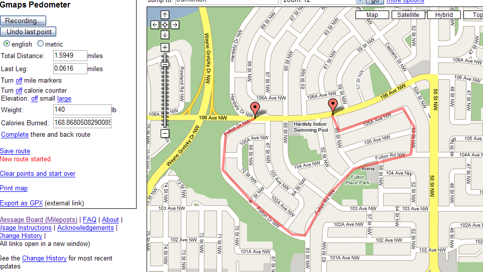
Gmaps Pedometer was one of the first distance-logging tools created using the Google Maps API. It works well for tracking running/biking routes, and includes a calorie counter based on your weight, as well as some rudimentary elevation information. However, the interface is somewhat bland, and this app doesn’t include some of the features found on some other routes, such as a central repository of user-created running routes integrated with the main app. You can save your running route, however, and users have shared their creations in their forums. No registration is required (or available) for this site. You can easily print maps from within the interface.
Overall, it’s an simple, but effective and easy way to track your distance. It’s somewhat plain though, and a little lacking on features. You also have to enter each point manually, since there’s no option to follow roads. So, if your path goes down a curved boulevard, you’ll have to click along each point to keep the distance accurate, since the path just follows straight lines between each point.
WalkJogRun
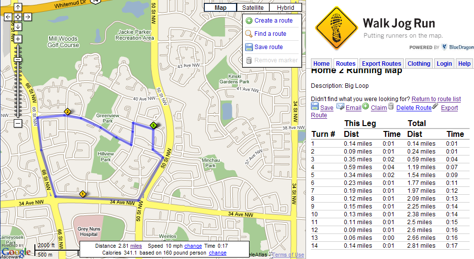
WalkJogRun is an application that has a large number of user-created running routes integrated with the map. You can find routes near your location simply by searching for your city; markers will then show up on the map indicating where these running routes are. Clicking on a marker will bring the running route onto the map as an overlay, along with distance measurements for each point along the route. Zooming the map can be done with the mouse wheel, just like in the regular Google Maps.
Times are also included, and are in hours:minutes, and are based on a speed you select. You can configure the distance/speed measurements to be in kilometers or miles (I still like miles, despite being raised metric for everything), and a calorie-counter based on your weight is also included. These options are at the bottom of the screen, and are fairly small, and could be relocated for better visibility.
You can also create your own route by double clicking to enter points. Creating running routes and saving them doesn’t require you to register, but you can, and have to, if you want to mark them as private or be able to come back and alter them later. This seems fair enough, and it’s good that they don’t force you to register to use the service. Also, it’s very nice to be able to see/search for other people’s routes right within the application. Overall, the interface of WalkJogRun seems quite refined, and is fairly easy to use. There are plenty of features, and you can even export routes to Google Earth.
However, one thing to note is that this application feels somewhat sluggish. This is no doubt due to the heavy use of the Google API and the resulting number of Ajax queries that must take place, in order to update the map with users’ routes as you reposition it. This is in stark contrast to Gmaps Pedometer, which while simple and plain, is also faster and more lightweight. I suppose it’s a trade off. And, like Gmaps, WalkJogRun doesn’t support a “follow by road” feature, so entering in paths down curved roads will take more time.
MapMyRun

MapMyRun is like WalkJogRun in that you can search for user-created running routes and also add your own to the mix, and it also has a fairly decent interface that shows information in both kilometers and miles. It has the nice feature that auto-saves your route, and restores it should you accidentally navigate away from the page. It also also gives calorie counts, and supports elevation data as well. You can save this information to a training log, but this requires that you register with the site.
When creating routes, you can specify different types of waypoints, for example water breaks, aid stations and bathrooms. Notes can be added to the waypoints, and the route can be printed out with these notes to keep them handy. This is very nice for operation in the real-world. You can export the route to a variety of sources, such as Google Earth, a Garmin Forerunner or Edge GPS device, or to your blog as some embedded Javascript. This is also very handy, as information nowadays should work across a variety of devices.
However, the best feature is that this application can automatically create paths that follow roads. This is good if your routes follow through a lot of curved roadways, as it’ll save you the headache of manually entering in the path. However, sometimes it’ll automatically create a path from one point to another that doesn’t follow the road route you’d probably run – this is a limitation of the Google Maps system, as it is probably calculating how a car would drive from one point to another. (For example, you can run either way down a one-way street, but cars obviously cannot) Another nice feature is being able to remove a point in the middle of your route without having to re-enter all the subsequent points.
While this application is feature-filled, it also suffers from some sluggish performance like WalkJogRun.
Run.com

With Run.com‘s application, you can also search for user-created running routes and add your own. The application is fairly responsive, and doesn’t feel too sluggish because of the way they’ve implemented it – searching for routes shows them on one map, and when you click a route to bring it up, it loads a new page with the route map. This reduces Ajax-activity that is often the cause of poor performance in web applications.
Routes show elevations, and distances in metric or imperial. Different waypoints (water break, aid station, scenic view) can be specified, and users can enter descriptions as well as difficulty ratings for each route. Tips entered by the person who created the route are often useful. (Eg. BE CAREFUL – LOTS OF BIKES
)
Though I don’t have much to say about this application, I actually think I like it the best. Even though it doesn’t provide all the data or features that WalkJogRun or MapMyRun might, it’s lightweight, fast and easy to use, all of which are important hallmarks of any application, especially web apps.
One last thing
You don’t need to use one of these tools to measure your running distance. You could easily use Google Earth‘s measure tool to map out your running route, but it’s a bit tedious, and these online applications will greatly simplify the process. Personally, I liked WalkJogRun and Run.com’s offerings the best, but you should give them all a try to see which fits your style best.
Lastly, these tools are probably best for road running, such as planning training for a marathon of some sort, or for the marathon itself. If you do a lot of trail running, they won’t work that great, since most of that data isn’t available on Google Maps, the basis for all of these tools. However, these tools do a good job of highlighting the features and flexibility of the Google Maps API by showing what can be accomplished.
This is a great article. Thanks. You should check out Microsoft Live maps too. They have some equally cool features.
Thanks for the write up – great summary of the highlights of each tool. As the owner of WalkJogRun.net it was interesting to hear what matters to someone who has worked with all of the tools. We’re working on v4 of the interface presently which is a lighter, faster version with room for more features.
All the best,
Adam
Thank you for posting this. I have recently been in the market for help on measuring my distance that did not involve me forking over $300 for a GPS watch. you’re awesome for being so innovative.
Michael
Good article. To get running distance you can also use this website:
Good article. To get running distance you can also use this website:http://www.sportdistancecalculator.com/
Sorry for double post 😉